If you operate a racetrack, a karting facility, or a motorsports park, your physical surface is the product. Every dollar of revenue you generate depends on that surface being in the right condition, configured correctly, and attractive to the drivers and organizations that book it.
But what do you actually know about your surface?
Not what you think you know. Not what it looked like when it was paved. What do you know about it right now? The exact elevation profile. The current camber angles through every corner. Where settling has changed the surface geometry since construction. Where drainage patterns have shifted. Where the pavement is degrading in ways you can't see from a walk around.
A LiDAR scan answers all of these questions with precision that no other method can match. And the data it produces doesn't just help you understand your track. It opens revenue streams, improves safety, and positions your facility for the future of motorsport.
Here's why it's worth considering.
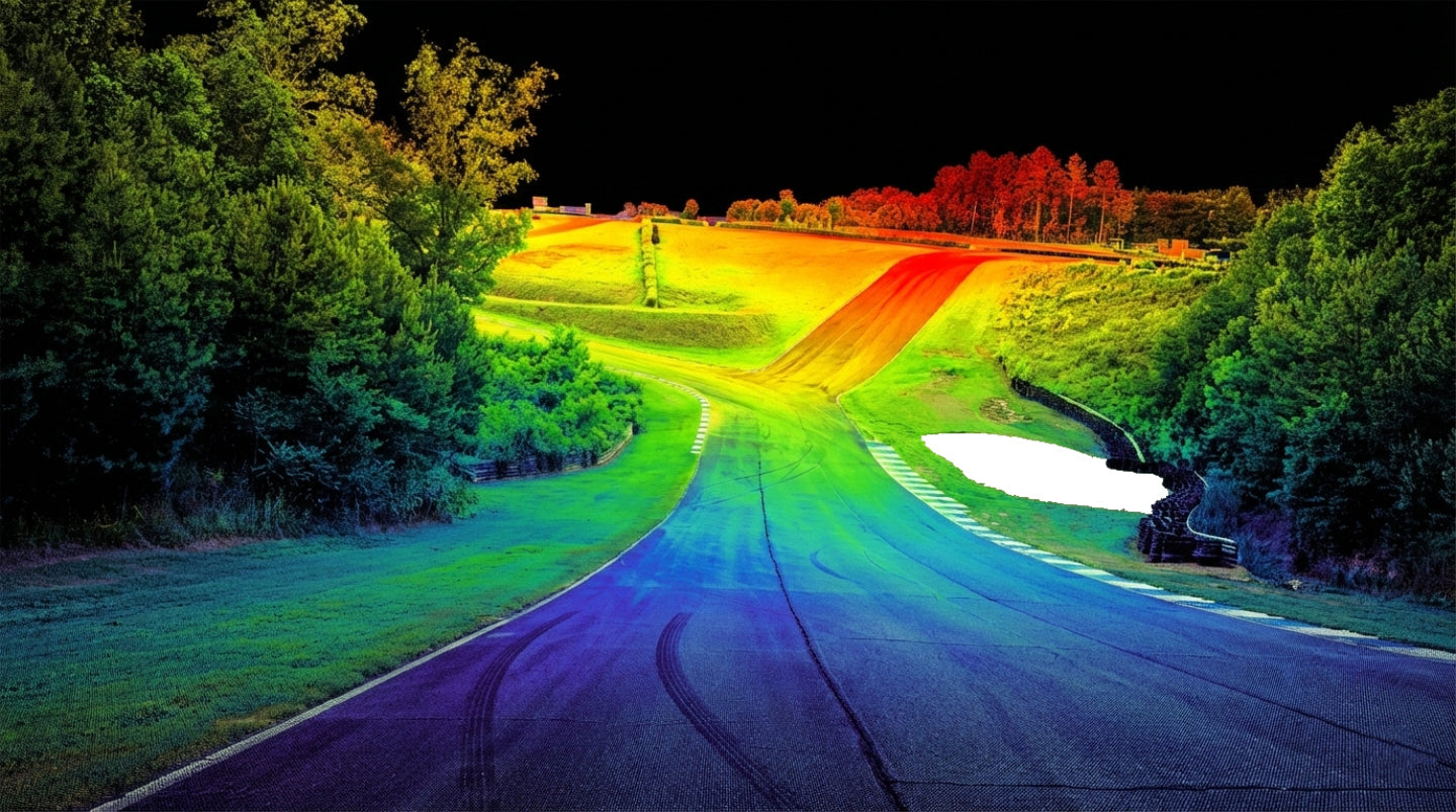
You Get a True Baseline of Your Facility
Most track operators inherit a surface that was built to spec years or decades ago. The original engineering drawings may or may not still be accurate. Asphalt settles. Concrete shifts. Drainage patterns change. Weather and use create subtle deformations that accumulate over time.
A LiDAR scan captures your facility exactly as it exists today. Every meter of surface, every elevation change, every curb profile, every transition between surface types. The result is a three dimensional digital model of your track that serves as a definitive baseline.
That baseline is useful in ways that might not be immediately obvious:
Maintenance planning. When you can see precisely where surface deformation is occurring, you can target repairs before they become safety issues. Instead of repaving an entire section because "it looks rough," you can identify the specific areas where the surface profile has changed beyond acceptable tolerances.
Safety analysis. Sanctioning bodies, insurance carriers, and racing organizations increasingly expect data driven safety assessments. A LiDAR scan provides measurable information about runoff distances, wall positions, surface irregularities in high speed zones, and elevation changes that affect vehicle behavior. This isn't subjective. It's engineering data.
Construction and renovation verification. If you're investing in resurfacing, extending a section, or modifying your layout, a pre construction scan gives you a benchmark. A post construction scan confirms that the work was completed to spec. You're no longer relying solely on the contractor's assurance that the camber is correct. You can measure it.
Your Track Becomes Available in Sim Racing
This is the revenue angle that most track operators don't realize exists.
When your facility is LiDAR scanned, that data can be used to create a digital version of your track for sim racing platforms. A version that doesn't just look like your track, but drives like your track. Accurate elevation. Accurate camber. Accurate surface detail. The real thing, digitized.
Why does this matter for your business?
Drivers prepare on your track before they arrive. A driver who can practice your circuit in a simulator before their track day or race weekend is a driver who gets more value from their real world session. That driver is more likely to book with you again, more likely to recommend your facility, and more likely to choose your track over a competitor that doesn't offer sim preparation.
Sim racing communities promote your track for free. When your circuit is available on a popular sim platform, thousands of virtual drivers experience it. They learn the layout. They develop an attachment to it. A percentage of those drivers will want to visit the real thing. Your scan data becomes a marketing tool that works 24 hours a day without costing you a cent in advertising.
Racing leagues and organizations value scanned facilities. Series organizers who use simulators for driver preparation and pre event analysis prefer tracks with accurate digital versions available. Having your facility scanned and represented in sim can be a factor in attracting sanctioned events.
Coaching and driving school programs benefit directly. If your facility hosts driving instruction, a scanned sim version of your track allows coaches to brief students before they get on the real surface. This reduces on track learning time, improves safety, and increases the perceived value of the coaching program.
Digital Twin Capabilities
A LiDAR scan doesn't just produce a pretty 3D model. It produces a digital twin, a geometrically accurate virtual copy of your physical facility that can be used for analysis and planning far beyond what a visual inspection allows.
Event planning and layout changes. Want to test a new pit lane configuration? Evaluate a different corner entry barrier placement? See how a chicane modification would affect the racing line? With a digital twin, you can model these changes virtually before spending money on physical modifications.
Drainage analysis. Water management is one of the most common and expensive problems track operators face. A high resolution elevation model from LiDAR data reveals exactly where water collects, where it flows, and where drainage improvements would have the most impact. This is engineering data that would cost thousands to obtain through traditional surveying methods.
Facility marketing. A digital twin of your track can be turned into flyover videos, interactive 3D tours, and promotional content that shows potential customers exactly what your facility looks like. This is especially valuable for attracting out of area drivers and event organizers who may never have visited in person.
The Scanning Process Is Less Disruptive Than You Think
One of the most common hesitations operators have is the assumption that a LiDAR scan will require shutting down the facility for an extended period. In reality, modern scanning technology has made the process significantly faster and less intrusive than it was even five years ago.
Ground based scanning can be conducted during off hours or between events. A skilled team can capture a full circuit in one to two days depending on the facility size and complexity.
Drone based LiDAR has accelerated the process even further. An aerial scanning system can capture the broad surface geometry of an entire circuit in a matter of hours, with ground based detail scans supplementing specific areas that need higher resolution. The combination of aerial and ground scanning dramatically reduces the time your facility needs to be clear of traffic.
Most operators find that a scan can be completed with minimal disruption to their normal operating schedule.
Cost Versus Value
A full LiDAR scan of a racetrack is not free. Depending on the size of the facility, the level of detail required, and whether you're using ground, aerial, or combined scanning methods, costs can range from several thousand dollars to tens of thousands for the largest and most complex venues.
That sounds like a significant expense until you consider what the data produces:
A maintenance planning tool that saves you from unnecessary repaving costs. A safety analysis document that supports your insurance and sanctioning body relationships. A digital twin that facilitates smarter renovation decisions. A sim racing asset that drives customer engagement and attracts new visitors. A marketing tool that differentiates your facility from every competitor that hasn't been scanned.
The scan pays for itself. The question is not whether the return is there. It's how quickly you want to start capturing it.
Who Should Do the Scanning?
This is worth addressing because the quality of the scan matters as much as the decision to get one.
A LiDAR scan for motorsport purposes requires more than just pointing a scanner at the ground. The team performing the scan needs to understand what matters for racing surface analysis and simulation. Point density on the racing surface needs to be high enough to capture curb details and subtle surface variations. Registration between scan positions needs to be precise. The data needs to be processed and delivered in formats that are usable for both engineering analysis and sim racing development.
Look for a scanning provider with experience in motorsports applications, not just general surveying. The requirements are different, and the output needs to serve different purposes than a construction survey or a topographic map.
The Competitive Advantage
Here is the reality of the motorsports facility market in 2026: the industry is becoming more data driven, more digitally connected, and more competitive every year. Drivers have more choices about where to spend their track time. Racing organizations have more options for where to hold events. Corporate clients comparing venues have more information available to them than ever before.
A facility with a complete LiDAR scan, a digital twin, and accurate sim racing representation has a tangible advantage over one that doesn't. You're not just selling a track surface. You're selling an ecosystem that extends from the digital world to the physical one and back again.
The tracks that recognize this and invest accordingly will be the ones that attract the next generation of drivers, events, and revenue. The ones that don't will be competing on price alone, and that's a race nobody wants to be in.
RRG Racing's sister company L2F Racing specializes in LiDAR scanning, track data, and digital twin development for motorsports facilities. Based at Atlanta Motorsports Park in Dawsonville, Georgia, we understand what track operators need because we operate alongside one. Visit rrgracing.com to learn how scanning can work for your facility.
Share:
Adding Simulators to Your Motorsports Venue: What Operators Need to Know
How Accurate Is Your Local Sim Track? The Role of LiDAR in Track Fidelity